
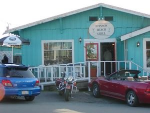
Touring With EBass in Southern Marin County
South Marin County, CA is ridiculously blessed with natural treasures. Route 1 snakes along a dramatic coastline. Forests and hills offer an escape from the urban jungle on the other side of the Golden Gate Bridge. Above it all, Mount Tamalpais rises up into the clouds and affords a unique perspective on the world at its feet. If you looked down to the west and examined the tiny speck of that world known as Stinson Beach, you would likely find a crowd of happy, hungry people gathering at the Stinson Beach Grill. And if you happened to be a sadistic little pre-pubescent miscreant throwing rocks at the gleaming shiny spot at the edge of the patio on a sunny afternoon in February, you just might have brained yourself a real honest to God motojournalist. Which would have sucked for me.
While the Stinson Beach Grill features an elegant indoor dining room, most everybody heads for the far larger and more popular outdoor patio. Heat lamps are on hand should the weather turn cool and the navy blue decking and tablecloths accompanied by white chairs and railing give a nautical feel to the 20 or so tables. At 2:45 on Saturday, usually a dead time for restaurants, the service still took awhile as they were nearly full up, always a good sign. The view of the mountains was already whetting my appetite. What a great staging area for an afternoon ride, but first I would be needing some sustenance.
They arrived grilled on the half shell and served with a shot of BBQ sauce for $10.95. The grilling firmed up the meat slightly, eliminating the slooshiness that so many people object to, and the tangy BBQ sauce added a complementary flavor without overpowering the oyster. The little crustaceans were tasty but hardly filling for my distended gullet so I chased them with the chicken sandwich with roasted red pepper and chipotle aioli on a sweet roll for $9.95. A tasty $7 glass of Markham Sauvignon Blanc would have been a fitting end to this hearty repast. However, since I had a ride ahead of me, the alcohol would have to wait until the end of the day.
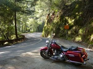
After my food digested and I was ready to roll, I headed north on Route 1, passing alongside the narrow Tomales Bay. Buffered by hills on either side, the bay is home to all manner of critters, birds, and fish and the occasional stray motorist who becomes so enraptured in its beauty that he forgets to keep his eyes on the road. Five miles later, I entered a canopied forest where the serpentine two-lane 25 mph road through solar eclipsing foliage makes you feel like some sort of moto-hobbitt. I half expected a clan of trolls to pull a clothesline across the road and jack me for the Road King.
One unusual aspect of this route is the preponderance of bicycle riders accompanying you for the mountain climb and descent. You'll need to be very aware of them as they tend to drift unpredictably towards the middle of the lane and may have headphones on and not hear your rearward approach. Granted, even on a 350 lb canyon carver you'd undoubtedly win any elbow rubbing contests, but who wants to have to pull over to pick chunks of fuscia and teal bike shorts out of their sprocket teeth?
Sir Francis Drake Bvd. started out as a well paved two-lane road that took me through a pasture of fenced grazing cattle who seemed completely disinterested in the hog passing through their midst. After shaving my floorboards down a bit on a pair of sweepers, a sign warned of winding roads for the next six miles as I commenced a hillside descent. When I reached a placard notifying me that Samuel P. Taylor State Park was soon approaching, the road surface deteriorated dramatically with shallow potholes and patches littering the entry to a 15 mph tight left hand corner. That's beauraucrat logic for you. They repave all the straights but leave the gnarliest corner on the road all jacked up. Just wonderful.
You'll pass a golf course on your right, and this being CA, the Spirit Rock Meditation Center on your left. I'm guessing this arrangement is some sort of one-stop marriage counseling deal. You drive there together, wander off to opposite sides of the street and a few hours later both come back happy!
Five miles past Lagunitas, the road bent to the right and I began a twisty valley passage for about two miles after which I arrived at the town of Fairfax, which was a veritable metropolis compared to Lagunitas. There was quite a bit of street traffic for a Saturday and 25 mph was as fast as you could possibly go. Shortly after reaching the town's border, you'll see a Chevron on the corner of Claus Drive. Turn right for about 20 feet then hang a left onto Broadway for another 40 feet and chop a right onto Bolinas Road heading SE.
Over the course of about 1/4 mile, the name will change from Bolinas Road to Avenue to Road again. Why politicians do silly things like this I couldn't tell you but don't let the bastards confuse you. They've got even more of the same in store for ya' up ahead. You'll soon reach a three-way fork where you want to stay to the left on Bolinas Rd. towards Mt. Tamalpais. After the fork, the road ascends up a hill away from town and gets nice and curvy but its best to exercise restraint. The surface is patched and pitted, but that wasn't as big concern to me, as the fact that I was passing through a residential mountain area for about a mile. No sense pushing it when the tailgate of a pickup truck can come sticking out of a driveway any moment and ruin your whole day.
About two miles up, Bolinas Rd. turns into Fairfax-Bolinas Road (see, I told you). The canyon leveled out briefly and as I passed by the second golf course of my journey I bemoaned the incompatibility of motorcycles and golf bags and began conceptualizing a Caddyshack trike. With holders for two sets of clubs and a cooler out back, you could ride it right up onto the course as your golf cart with stereo thumping ala Rodney Dangerfield. Hey, Leno would buy one for sure!
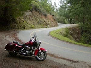
My Monster Garage fantasy was rudely interrupted by a "winding road next 8 miles" sign, then a tight left corner and a big left sweeper that commanded my full attention. After a mile of slithering hillside ascent, the two-lane road descended again into forest. Short straightaways tempted me to pick up speed, especially going downhill, but they were usually punctuated with decreasing radius hairpins with cliffside drop offs at their apex. The road also contained loose gravel and wet leaves at times, as well as sporadically poor surface conditions, and I learned to resist temptation and expect the unexpected. I wasn't really in the mood to have to call the folks at Harley-Davidson fleet center on my cell phone to explain why I needed them to send a helicopter to medevac me and their Road King out of a tree.
After about six miles of forest, Alpine Lake appeared on my left and I crossed over a short dam, which despite its decided lack of drama, appeared to attract tourists like a free meal attracts Dean Adams. No sooner had I reached the other side than I was greeted by a wicked left hairpin followed by a 1st gear right hairpin. The road narrowed at this point, and to make matters even more prickly, it was lined with parked (and parking) cars and tourists walking alongside on their way to check out the dam. What is it with this damn dam anyway!
Heading up into the forest, the assault of savage hairpins continued and a fair amount of wet leafy debris in the road did nothing to bolster my confidence. Semi-invisible ripples in the road surface made themselves known from time to time and a few of the hairpins contained mid-turn surprises. First gear got a lot of use but I kept the rubber side down and actually enjoyed the dense forest ambiance on my way to the crest.
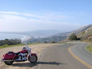
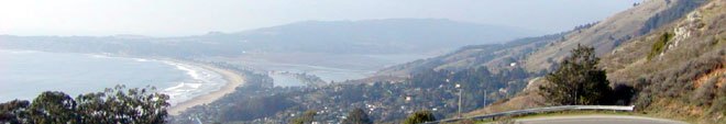
Three miles past Alpine Lake, Fairfax-Bolinas Rd. forks with Ridgecrest. By staying to the left you'll enter the State Park where the forest suddenly falls away to reveal sunshine, blue skies, softly rolling brown hills and undulating, smoothly paved, two-lane road. A majestic view of the coastline appears to the west and the contrast of this wide open "top of the world" wonderland with the narrow twisting tube of dense oak forest from which I had just emerged felt like a passage out of a fairytale. Four miles into the park, I reached a large parking lot and an intersection but continued straight for another three miles to the East peak of Mt. Tamalpais. This last stretch ascended to the mountain's full 2,571-foot elevation and was shrouded by clouds on the day I went. It felt as if I was a neo-Viking riding to Valhala.
After turning around back towards the main parking lot, I headed south onto Pantoll Road. Well, at least for a few hundred yards to the first viewpoint turnoff. It's one of those postcard perfect spots that you just have to stop and appreciate for awhile. Clear of the cloud cover, I was able to survey the Marin County hills, San Francisco and the East Bay, and even the Farallon Islands. At times like these, when I encounter something so undeniably romantic while traveling alone, I really wish you could just rent a girlfriend from a roadside vendor for about 10 or 15 minutes. They could have a small selection to choose from, and you could pick one and just stand there innocently holding hands, or maybe even for a mutually agreeable sum, put your arm around her waist. I think when I finish building the MO-project golf trike, I'll look into starting a chain. I could call it, "MO's Mountain Maid Mini-mart". Yeah, that's the ticket baby!
After soaking in the astounding coastal scenery for a bit whilst plotting my flesh-peddling service for socially inept bikers, I continued descending the mountain along the curvaceous cliffside route. The fantastic ocean views are so mesmerizing that the internal debate between strafing the bends and cruising for the view developed into a case of near schizophrenia. After one mile, Pantoll Road T-bones with the well-paved two-lane Panoramic Highway where you'll turn right, heading east towards Stinson Beach.
Passing through some downhill wooded twisties, I arrived quickly at a series of five sneaky, decreasing-radius lefts. After the third one a small white cross and wreath appeared, indicating a memorial for someone who had died at that spot. I'll never know whether they were on a bicycle, motorcycle or in a car, but the point was made in my mind. Respect your limits and the x-factors that can present themselves on a public road. If it's glory your after, get thee to a track and go for the gusto!
Panoramic Highway couldn't be more aptly named. For once, the beauraucrats got something right. After two miles of lush redwood groves, you are treated to a dramatic emergence from the forest to a beatific view of the coastline. I recommend utilizing the turnoff immediately to your left as an opportunity to admire the view undisturbed by the need to mind your traction. Just a few yards ahead things are gonna get really wicked for the next two miles. A pair of left-right hairpins so sharp that you can practically read your own license plate are soon followed by another pair for good measure. Visibility and road conditions are quite good, so you can really work on your line here. If I wasn't waddling along on the Road King, I would have done just that for the better part of an afternoon.
Between the challenging but rhythmic pinchers through the forest and the neck snapping hairpins graced with stellar views, the Panoramic Hwy has to be one of the best four miles of road I've ever been on. At the end, you'll T-bone with Route 1. Turn right and head north, and the Stinson Beach Grill will appear just 1/4 mile ahead on your left. If you aren't aroused enough, you can always grab a few more oysters for good measure or just replenish your calorie count with whatever tickles your tummy. I could just imagine using the SBG as my base camp for a whole afternoon of pumping up and down the Panoramic Highway. Yowsa that was fun! Next time, I'm coming with an R6... and maybe even a mountain maid!
Stinson Beach Grill
3465 Shoreline Hwy.
Stinson Beach, CA 94970
415-868-2002
Route mileage: 66 miles
Total time including restaurant: 5 hours
More by Eric Bass


Comments
Join the conversation