


Tortilla Flat & the Superstition Saloon, on the Apache Trail
Legend has it that the Superstition Saloon was established by Jacob Waltz, "The Dutchman," who was either the man who discovered the Mother Lode (the "Lost Dutchman Mine") in the surrounding Superstition Mountains, or was one of history's greatest liars.
Whichever the case, we know that he didn't really start up the Saloon, as its true history has it first being established as a stagecoach stop on the route from Mesa, Arizona, to the site of Roosevelt Dam.
Though this building was last rebuilt after being almost totally destroyed by fire in 1987, great care was taken to make it look and feel as much like the original as possible, and unless you were intimately familiar with the original, 100-year-old Saloon, you would swear it had never burnt down. That includes the thousands of dollar bills covering almost every inch of the walls, left there by visitors from over 70 different countries.
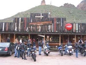
The Superstition Saloon doesn't take reservations, and during the tourist season or on weekends, be prepared to wait a half-hour or more for a table. The thing to do is to put your name on the waiting list as soon as you arrive, then wander through the gift shops and weird antique displays until your name is called. Or, during the summer months, you can eat out on the patio, where there is no waiting. Open from the day after Christmas until Easter Sunday, the patio features an open barbeque grill serving hot dogs, BBQ chicken, half-pound hamburgers and, of course, Killer Chili. The patio also features a live western band and local comedians.
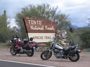
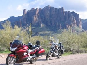
Tortilla Flat lies on The Apache Trail, so named because it was originally used by the Apache Indians as a route for raiding parties attacking the tribes that lived in the valleys below. It was later turned into a road for transporting men, supplies and equipment up to the building site of the Roosevelt Dam, in 1904. Leaving Tortilla Flat and heading north, the Trail winds up and down through spectacular scenery for about five miles before turning from a modern paved road to dirt and gravel. This route is graded and in pretty good condition most of the time, but can be rutted and difficult after a heavy rain. You would do well to check with one of the locals before heading up the Trail on your motorcycle.
Though the Apache Trail is normally not a problem, even for street bikes, if you are nervous about riding on dirt, or if you ride a particularly low-slung cruiser, you might be better off riding in the opposite direction, where all the roads are paved, and turning around after exploring the Lost Dutchman State Park. But for the rest of us, let's head up the Trail. Mileposts mark the route, and we'll navigate by them.
Milepost 220 is where the pavement ends, and at milepost 222, we begin our descent of Fish Creek Hill. Take a deep breath, and prepare yourself for the most challenging stretch of the Trail because if you haven't had much opportunity to practice off-road braking on your motorcycle, that ends now. In the next three miles, you will drop 1,500 feet in elevation, to a small bridge at the bottom of the canyon.
We come to Apache Lake Vista at milepost 228, and it is time to get out your camera. Trust me.
About six more miles up the Trail, you will begin paralleling a deep, wide river leading up to Roosevelt Dam. As the dam comes into view, you will be awed by its size. Still the largest masonry dam in the world, at 280 feet high, it was built almost entirely by hand by Apache laborers.
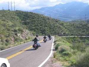
At milepost 244 you have reached the official end of the Trail. From here, we will turn right on Highway 188, back on pavement again, to Miami, beginning a wide circle around the Superstition Mountains. At Miami, 188 merges with Highway 60 to Superior. This is a wide, well-maintained highway, yet with fabulous mountain views and lots of those wide, sweeping curves that are such a delight when you are on two wheels. From Superior we will head up even higher into the mountains, going over Gonzales Pass. From the top of the pass, you can see almost the entire Salt River Valley below, wherein resides Phoenix. Be prepared for a drastic climate change. From the top of Gonzales Pass to the valley below, a distance of only about 10 miles, the temperature will rise as much as 30 degrees! At the bottom of the pass, you have a straight desert stretch of about 30 miles ahead of you, but with almost ghostly views of the Superstition Mountains on your right. Try to imagine the thousand of fortune hunters who have searched this almost impassable terrain in search of the Dutchman's gold.
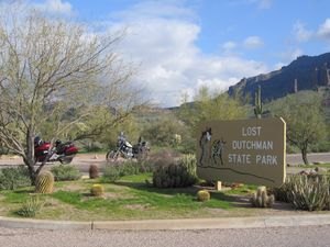
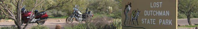
Entering the town of Apache Junction, you meet up with the Trail once again, Highway 88, and will turn right to head into the mountains again. This is the official "start" of the Trail, a well maintained two-lane, winding through a wild and rugged stretch of desert with towering cliffs and plunging canyons. Just past milepost 200 is the ghost town of Goldfield, and next to it is the Lost Dutchman State Park. This would be the turning-around point for those riders who came here "backwards" from Tortilla Flat, rather than brave the unpaved parts of the Trail.
At milepost 203 is Weaver's Needle Vista. A towering spire of granite, visible for a hundred miles, Weaver's Needle is also a part of the famous Lost Dutchman legend, and most accounts claim the hidden mine lies somewhere in its shadow. Just five miles later, at milepost 208, is the Canyon Lake Overlook, with arguably the prettiest view of the whole ride.
From here, you'll ride down into a valley and alongside Canyon Lake for several miles, past marinas and picnic grounds, before a quick and twisty ride back up the other side to Tortilla Flat. The entire route covers 124 miles, but because of the dirt roads and winding, mountainous conditions, you'll need to allow about four to five hours for the journey. There's much more to see than is described here, including giant, open-pit copper mines, dry lake beds, glittering desert floors, littered with semi-precious stones, and mountain vistas to take your breath away. Don't miss it.
Superstition Saloon & Restaurant
1 Main Street
Tortilla Flat, AZ 85290
http://www.tortillaflataz.com/
(480) 984-1776
[email protected]
No reservations accepted.
Visa, MC and Discover OK with minimum $10 purchase.
More by Fred Rau


Comments
Join the conversation