


Top 10 Best Motorcycling Touring Roads
‘I've been everywhere, man; I've been everywhere, man; across the deserts bare, man; I've breathed the mountain air, man; of travel I've had my share, man; I've been everywhere.’ —Johnny Cash
Even for Johnny Cash, it would be a mighty feat to ride America’s 3.9 million miles of highways, byways, avenues and alleys to get, as the song says, “everywhere.” Although sometimes it may feel like we’ve traveled every road worth a ride, the biker DNA bubbling in our blood tells us there is, somewhere, the spectacular road not taken.
Not that we haven’t tried to ride everywhere. Aside from a few heated water-cooler debates, varying levels of certifiable psychosis, polite differences of opinion and immeasurable variables of riding style, the staff at Motorcycle.com carefully considered its 300 or so years of collective biking experience and named these the Top 10 touring roads in the U.S., although no peaceable agreement could be made as to order, except for the fistfight averting alphabetical.
Print this, stuff it in your leather shirt, get off the couch and on your bike, and find some damn adventure.
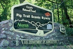
Arkansas Highway 23
If all you hear is “Dueling Banjos” when you think of Arkansas, take a closer listen. From Huntsville to the Missouri border, nearby Mark Twain National Forest and popular Branson, the countryside whispers a verdant symphony. Like riding through a Norman Rockwell painting, the road takes us to a more pastoral time.
Near the college town of Fayetteville in the northwest corner of Arkansas, Highway 23 rounds through the heaving breast of the Ozarks, traveling north to the historic town of Eureka Springs. Its steep hills and hairpin turns has earned it the name, the Pig Trail Scenic Byway.
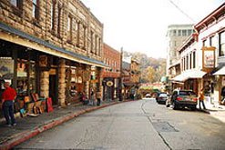
Eureka Springs dates to 1879 when it boomed, not because oil, natural gas or gold was discovered, but rather a spring. The healing wonders of its cold springs transformed it into a spa town. They came by stagecoach, wagon, horse, rail and, for a while, two-wheeled contrivance. The spa era ended circa 1910, but the architecturally rich town remained as a favorite holiday destination, being designated a nationally significant Historic Place.
Benedict Arnold Highway (Maine State Route 201)
While we found it odd that someone thought to name a road after one of our most infamous traitors, Arnold would have been proud of the nod. For some 52 miles from the town of Moose River to Solon, the route cuts through thick spruce and fur like Paul Bunyan. The road looks like a big, black slice through the wilderness.
The Kennebec River and scores of streams and ponds flank the Benedict Arnold, which will feel like a personal paradise for riders who like an impromptu summer dip. Just watch out for the moose, and maybe an occasional bear or Bigfoot.
A few miles north of Moose River is the Canadian border. Beyond the 30-minute customs stop, the road turns to rolling farmland. I doubt neither Thompson nor Cash would care to account for every pill and prescription, or if Quebec is worth the wait, but that choice is what biking’s all about.
Natchez Trace Parkway
This is a 444-mile National Park stretching from Nashville, TN to Natchez, MS, skirting a bit of Alabama. No commercial traffic is allowed on this two-lane bucolic road, flanked by deciduous trees and inviting grassy areas.
Completed in 2005, the Natchez Trace covers 52,289 acres, and averages 800 feet in width. Points of interest pop up often along the lightly traveled route, which is thankfully without billboards. Along the way, you can spot segments of the original Natchez Trace Indian trail, Indian mounds, the grave site of 13 unknown Confederate soldiers, a cypress swamp, meandering streams, waterfalls, modest and major rivers, rolling farmland, and the huge Ross Barnett Reservoir and the sunbathers who worship it. There is no charge for the Trace’s campgrounds, but there’s no hot water or showers either.
Navajo (Arizona) Route 15
Locals have nicknamed this Volcano Road since scores of dead or dormant volcanoes and basalt outcroppings line the route, mostly on its western end. With Flagstaff just a few miles to the west, Navajo Route 15 begins at Winona, off I-40. Riding east, you’ll soon cross into the Navajo Reservation.
This is arguably the most unearthly road in our Top 10. Once the bottom of an ancient sea, the landscape is dominated by long, empty expanses of ancient seabed punctuated by colorful sedimentary rock, worn by eons of erosion into eerie buttes towering over the desert like silent sentinels.
Route 15 rolls through the Navajo town of Leupp, last chance for gas before Ganado, best known for the Hubbell Trading Post (the oldest continuously operating post in the U.S.). The road makes a quick jog north at Route 6 before it continues into the heart of the nation’s largest Native American reservation.
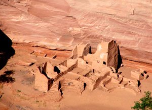
Riding east toward Greasewood, it turns into Route 191 on the way to Chinle, the doorway to the little known but spectacular Canyon de Chelly. A little further to the northwest lays Route 163 and the iconic Monument Valley seen in so many films.
New York Route 47 from Big Indian to Grahamsville
A few hours northwest of New York City, past scary Sleepy Hollow, beyond West Point and not far from Woodstock (and Bethel, where Jimi Hendrix redefined the electric guitar), at the intersection of New York Routes 28 and 47 stands the tiny town of Big Indian. Turn south on 47 and ride some 30 miles of some of the most bucolic road you’ll see on this planet, or any other planet.
Route 47 is in the heart of the Catskill Mountains. New Yorkers tend to refer to the area as the Borscht Belt for all the cheesy resorts that drew city dwellers away from the summer heat. If you like your dancing dirty, countryside breathtaking, and mountains with cutes names like Peekamoose, you’ll feel right a home.
Pacific Coast Highway (California State Route 1)
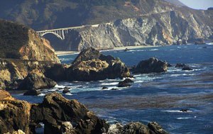
When asked what was the best ride he’d every taken, Hells Angels chronicler and mad biker, Hunter Thompson, didn’t bat a red, swollen eye: “Bombing down Highway 1 on acid,” to paraphrase the gonzo journalist. We don’t recommend the acid, or bombing, but Thompson was right about the road.
The twisty, cliff-hugging, 655-mile coastal highway offers sensational views and seaside towns for a large chunk of the California coast. From the Redwoods, across the Russian River, over the Golden Gate, into Carmel, Monterey, Big Sur, Malibu, Santa Monica, and Newport Beach, from the Bay Area to Los Angeles, the road offers most of the best of California.
In typical California fashion, the highway has more than one name. Depending on jurisdiction, local identity issues and regional rivalries, the road is alternately known as the Coast Highway, the Pacific Coast Highway (PCH), Highway 1, the Shoreline Highway, and the Cabrillo Highway. The entire route is also designated as the Blue Star Memorial Highway. To add more overlap, it’s also part of the longer Pacific Coastal Highway, which extends along pretty much the entire Pacific Coast of the Western Hemisphere.
Route 66
There is a certain cult status to making the pilgrimage from Chicago to L.A. Little of the Mother Road exists today, but a 70-mile stretch from Seligman west to Kingman, AZ looks much like it did half a century ago. There are few services in between so a stop at Seligman, a town dedicated to Route 66 kitsch, is a must.
Accommodations include the Historic Route 66 Motel, as much a museum as a place to rest. A&P’s Café and the Copper Cart Restaurant offer some tasty Route 66 fare, and check out Delgadillo’s Route 66 Gift Shop for that must-have souvenir.
Seligman is a gateway to Havasupai Falls on the Hualapai Indian Reservation, considered a hiker's paradise. Thirty miles from Seligman, near the Aubrey Cliffs, travelers can explore the Grand Canyon Caverns, which boasts some of the most fascinating stalagmites in the western U.S.
The Extraterrestrial Highway (Nevada State 375)
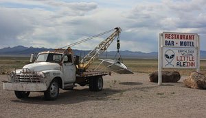
The road rolls from Outer Space to Area 51, the final destination of crashed alien spacecraft and tiptop government secrets. I’m still not sure which government, but no matter, I have a cozy little bungalow in planet Earth’s ultimate gated community.
Route 375 is in south-central Nevada near Nellis Air Force Range. Heading northwest along the ET road from the intersection of US 93 and 375, the highway peaks at 5,590 feet at Coyote Summit. As you descend into the valley, the tiny town of Rachel appears. If you ever wondered what the bottom of the ocean would look like, take a good gander. You’re a thousand fathoms under a retreated inland sea.
Rachel is the only outpost in this 98-mile black ribbon rolling over the burning desert. Have a bite to eat at the Little A’Le’Inn restaurant. Old mines and ghost towns are scattered along the Extraterrestrial Highway, which ends at Warm Springs and US 6.
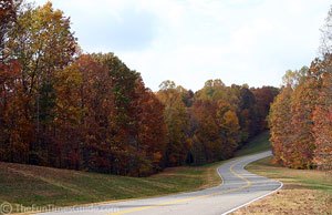
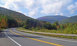
The Kancamagus Highway (New Hampshire State Road 112)
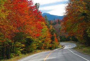
Not far from Laconia in New Hampshire’s White Mountains, some of the prettiest miles you’ll ever ride are the 34 between Lincoln east to Conway.
The gorgeous curves of Kancamagus Mountain follow the Swift River. Not only is this one of the world’s great fall foliage destinations, but an unforgettable summer escape for motorcyclists. The Kancamagus stretches across old Indian hunting paths, logging roads and dense forest.
Visit Clark’s Trading Post near Lincoln, which is not only an eclectic shop but a museum. Other attractions include the Conway Scenic Railroad and Loon Mountain, where motorcyclists can switch to mountain biking or horseback riding.
For an opulent contrast to the rugged scenery, check into the North Conway Grand Hotel. And for a bite of some local flavor, try the Muddy Moose Restaurant & Pub in North Conway.
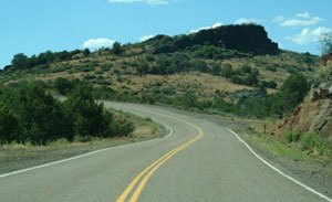
The Million Dollar Highway (US-550, Durango to Ridgway, CO)
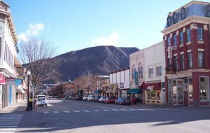
If you’ve ever been to the Four Corner’s Rally (also called Rally in the Rockies) you know why it’s nicknamed, “The Rally of Rides.” In 2006, the rally was cancelled less than 24 hours before the gates opened. Except for the organizers and exhibitors, almost no one cared. Bikers don’t come here to buy a T-shirt; they come to ride.
Beginning in Durango, US-550 (The San Juan Skyway) rolls past Purgatory, over 10,899-ft. Molas Pass, where I’ve personally been snowed on in August, down into the old mining town of Silverton, which doesn’t seem to know it’s no longer 1880. The scenic Skyway follows the Uncompahgre River, which runs a colorfully bright yellow in the area due to run off from mine tailings. It otherwise looks quite fresh but tastes metallic, if one were dumb enough to taste it.
The mountain continues on to Ouray and its waterfall and hot springs, which can bring new life to achy biker butts and shoulders. Ridgway is a nice turnaround point, or if you’re on a nice, cushy tourer, roll west onto Route 62 toward Placerville, then south on Route 145 to ski town of Telluride and beyond to Rico, Dolores, east on 184 to Mancos, then 160 back to Durango. The whole loop is about 260 miles and stunning. Keep a keen eye on the weather, though; it can turn from summer to snow in a few hours.
Related Reading
Two-Wheeled Touring in Quebec Maritime
Touring Ontario: Muskoka and Rainbow Country
Arizona Motorcycle Travel Destinations
Pacific Northwest Motorcycle Travel Destinations
New England Motorcycle Travel Destinations
California Motorcycle Travel Destinations
Ozark Mountain Motorcycle Travel Destinations
Virginia Motorcycle Travel Destinations
More by J. Joshua Placa


![Top Ten Hottest Biker Movie Women [Video]](https://cdn-fastly.motorcycle.com/media/2023/05/31/11750101/top-ten-hottest-biker-movie-women-video.jpg?size=350x220)


Comments
Join the conversation